The 2017 Food crisis during 2017 will directly affect 70 million people across 45 countries[1]. Emergency conditions began to appear in 2016, and the crisis appeared to strike East Africa and the Sahel particularly badly.
Food stresses often occur in isolated pockets, largely due to changing weather patterns, poor harvests, inconsistent seasons, malfunctioning markets, or lingering effects of previous disasters. But severe emergencies – such as those affecting large parts of Africa at present- are often man made. There are several reasons that current countries with emergency and famine are in such positions; these include conflict, mismanagement, and insufficient responses to previous disasters. As noted in a recent FewsNet report, the four states of Nigeria, South Sudan, Somalia and Yemen are most concerning. All are beset by conflict, yet not all are equally incapacitated to deal with food pressures because of violence.
Table 1: Summary Statistics on Food Risk and Violence
| Coverage | Conflict Average 2010-2016 | Conflict Rates Since 2017 | |
| Minimal | 59% | 42% | 30% |
| Stressed | 17% | 27% | 22% |
| Crisis | 21% | 22% | 28% |
| Emergency | 3% | 9% | 16% |
| Famine | .15% | .23% | .71% |
| Total | 33789 Grid Sqs. | 100% | 100% |
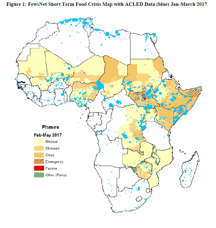
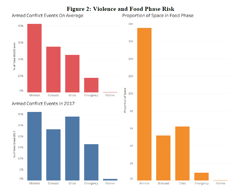
As displayed in figures 1 and 2, the majority of areas in Eastern, Southern and Western Africa are under “minimal” stress, while a third of that proportion are “stressed” or in “crisis”. A small proportion of the overall area is in “emergency” and “famine” conditions. Only South Sudan registers as having “famine” conditions, and within South Sudan, this is largely isolated to Unity State.
But the average conflict rates (in red, based on averages since 2010) and the most recent quarter (in blue, based on activity since January 1st 2017) suggest that conflict is lower than expected in “minimal” and “stressed” areas, proportional in “crisis” areas, and is over-proportional per-km in emergency and famine areas. This has only intensified since the crisis began, there is an approximate 75% increase in recorded violence in “emergency” areas and a threefold increase in “famine” areas.
The affected states and their conflict forms and rates suggest three key features:
South Sudan’s and Nigeria’s emergency and famine conditions are largely due to violence. In both cases, the areas of most concern are isolated in active conflict areas, where food prices are high, market activity is hindered and livelihoods negatively affected by conflict over the long term
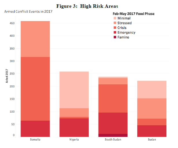
As demonstrated in Figure 3, Somalia has the highest rate of recent violence across the four heavily conflicted states, yet Somalia does not have more areas with emergency or famine risk. Somalia has an emergency area that is similar in size to Sudan’s, and below both Nigeria and South Sudan. Nigeria’s emergency is the most isolated, as a much higher proportion of the state is under minimal stress.
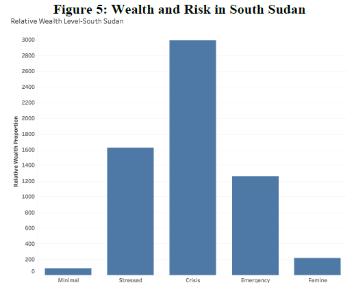
South Sudan’s case is particularly acute: Famine is very likely in Unity state. This suggests that the government is largely at fault for the famine that will affect South Sudanese citizens. Unity state is an important home/base area for the opposition (SPLA-IO) who has not recently conducted much activity against civilians or other armed groups in this space. The State has been active in both battles and attacks on civilians in Unity state. This results in famine risk being largely isolated in Nuer areas.
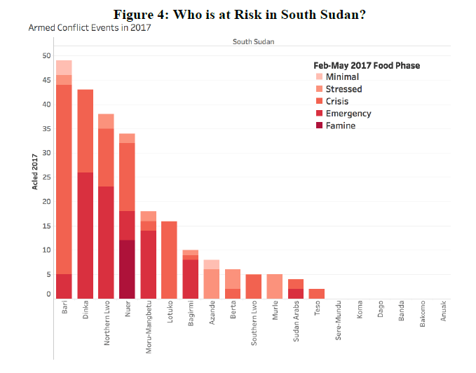
Most concerning about the South Sudan risk is its clustering. As demonstrated in Figure 4, in the short term, the risk is mainly found in Unity State, and mainly in areas populated with the Nuer people, which are associated with Riek Machar’s SPLA-IO organization. The SPLA (state military) are the main active group in Unity state where they engage in battles with the rebels and a high degree of violence against civilians. As the emergency and famine conditions spread in recent months, it will enter into areas where allies of the President have recently begun large-scale battles.
There is also no immediate reason to suspect that the underlying reasons for food emergency or famine conditions deviate from conflict. For example, neither conflict nor risk co-vary with distributed wealth, nor does conflict or risk cluster around resource areas.
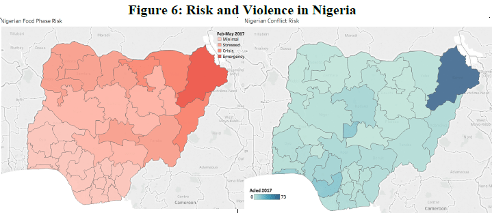
In Nigeria, there is a very clear-cut case of a conflict emergency borne of entrenched conflict and its legacy on development, livelihoods and resilience of populations.
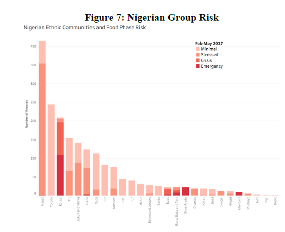
There is a clustering in the Northern area and groups that occupy that space, including the Kanuri and Shoa-Arabs.
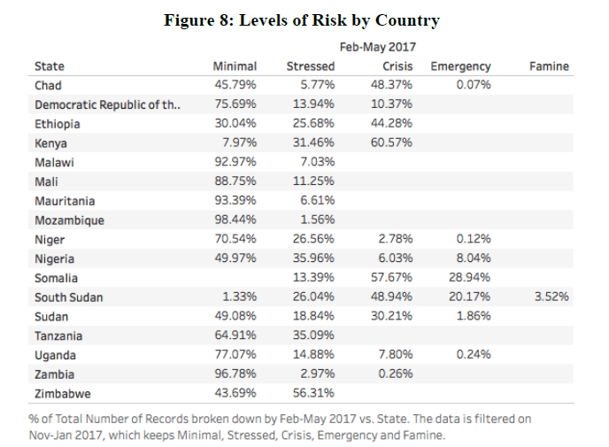
Other zones of emergency (e.g. Zimbabwe and Malawi) are affected because of high food prices and general mismanagement. Command agriculture in Zimbabwe has had negative repercussions since it was phased in during 2016; whereas Malawi – despite good rains this year- struggles with the legacy of two disasters in the 2015 floods and the donor funding crisis that followed a corruption scandal of 2013-4. The variation in food crisis phases and coverage is noted in Figure 8.
In summary, there is no singular, standard explanation for the variety of risk we see throughout East Africa and the Sahel. This crisis demands a reassessment of the links between famine, climate and conflict. There is little reason to believe that violence is higher in areas that are more vulnerable to climate change, relative to other areas within and across countries. There is little to suggest an increase of violence is clustered in ‘resource’ scarcity or abundant areas – such as waterholes and pre-crisis wealthy or poor zones. There are also cases of ‘missing conflict famines’- if conflict was the determinant to famine or emergency conditions, then Somalia, Sudan and the Middle Belt of Nigeria should see substantial famine conditions, while Zimbabwe and Malawi should be free of emergency conditions.
Method
The FewsNet map for ‘future crisis’ created using FewsNet Shapefiles for East, South and Western Africa for the period of Nov-Jan 2017 and Feb-May 2017. All data are available on the FewsNet website. Each map was joined and then grafted onto a grid of 33789 squares for localized analysis. Conflict data are from ACLED data at acleddata.com. Riots and protests are removed from the analysis.
[1] http://www.fews.net/sites/default/files/Food_assistance_needs_2017.pdf


